
Thank you for supporting this site ❤️
Make a donation
Make a donation
Gear up for your next adventure:
As an Amazon Associate, this site earns from qualifying purchases at no extra cost to you.
Airexe topographic map
Click on the map to display elevation.
Thank you for supporting this site ❤️
Make a donation
Make a donation
Gear up for your next adventure:
As an Amazon Associate, this site earns from qualifying purchases at no extra cost to you.
About this map
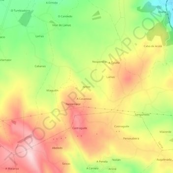
Name: Airexe topographic map, elevation, terrain.
Location: Airexe, Nespereira, Sarria, Lugo, Galicia, 27613, Spain (42.70254 -7.50938 42.74254 -7.46938)
Average elevation: 642 m
Minimum elevation: 499 m
Maximum elevation: 766 m
Thank you for supporting this site ❤️
Make a donation
Make a donation
Gear up for your next adventure:
As an Amazon Associate, this site earns from qualifying purchases at no extra cost to you.