Geolocate

Newton topographic map

Click on the map to display elevation.

About this map

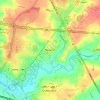
Name: Newton topographic map, elevation, terrain.

Location: Newton, Rugby, Warwickshire, England, CV23 0EE, United Kingdom (52.37850 -1.24202 52.41850 -1.20202)

Average elevation: 114 m

Minimum elevation: 85 m

Maximum elevation: 142 m

Other topographic maps

Click on a map to view its topography, its elevation and its terrain.

Wolston CP

United Kingdom > England > Warwickshire > Rugby

Average elevation: 89 m

Dunchurch

United Kingdom > England > Warwickshire > Rugby

Average elevation: 102 m

Draycote Water

United Kingdom > England > Warwickshire > Rugby > Draycote

Average elevation: 92 m

Gear up for your next adventure:

🧣Merino Neck Gaiter - Protects against wind, sun, and cold at high altitudes
🥾Waterproof Hiking Boots - Boots keeping your feet dry in wet conditions
🧤Insulated Winter Gloves - Heavy-duty protection for sub-zero Canadian adventures
🥾All-Terrain Hiking Boots - Versatile boots for varied hiking conditions
🌬️Windproof Camp Stove - Efficient cooking even on exposed mountain peaks

As an Amazon Associate, this site earns from qualifying purchases at no extra cost to you.