Geolocate

Dunchurch topographic map

Click on the map to display elevation.

About this map

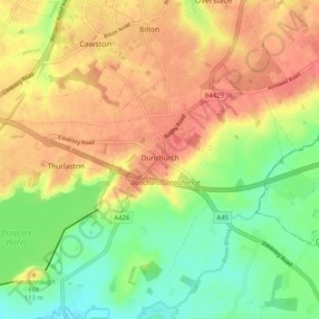
Name: Dunchurch topographic map, elevation, terrain.

Location: Dunchurch, Rugby, Warwickshire, England, United Kingdom (52.31337 -1.33811 52.36018 -1.25579)

Average elevation: 102 m

Minimum elevation: 71 m

Maximum elevation: 130 m

Other topographic maps

Click on a map to view its topography, its elevation and its terrain.

Draycote Water

United Kingdom > England > Warwickshire > Rugby > Draycote

Average elevation: 92 m

Draycote

United Kingdom > England > Warwickshire > Rugby

Average elevation: 94 m

Newbold on Avon

United Kingdom > England > Warwickshire > Rugby

Average elevation: 98 m

Bilton

United Kingdom > England > Warwickshire > Rugby

Average elevation: 111 m

Newton

United Kingdom > England > Warwickshire > Rugby

Average elevation: 114 m

Bramcote

United Kingdom > England > Warwickshire > Rugby

Average elevation: 105 m

Barnacle

United Kingdom > England > Warwickshire > Rugby > Barnacle

Average elevation: 102 m

Newton

United Kingdom > England > Warwickshire > Rugby

Average elevation: 114 m

Gear up for your next adventure:

🩹Compact First Aid Kit - Pre-packed essentials for common trail injuries
💧Hydration Bladder - Hands-free hydration solution for long treks
🥾Light Trekking Boots - Supportive boots for multi-day treks
🩹Moleskin Blister Pads - Direct protection for painful foot pressure points
🧥Packable Rain Jacket - Breathable waterproof layer for unpredictable weather

As an Amazon Associate, this site earns from qualifying purchases at no extra cost to you.