Geolocate

Florida topographic map

Click on the map to display elevation.

About this map
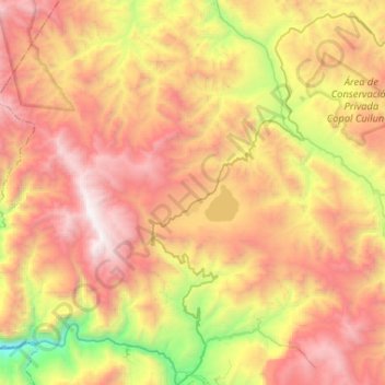
Name: Florida topographic map, elevation, terrain.

Location: Florida, Province of Bongará, Amazonas, Peru (-5.89039 -78.10229 -5.74026 -77.84234)

Average elevation: 2,265 m

Minimum elevation: 873 m

Maximum elevation: 3,545 m

Other topographic maps

Click on a map to view its topography, its elevation and its terrain.

Santa María de Nieva

Peru > Amazonas > Nieva

Average elevation: 209 m

Plazapampa

Peru > Amazonas > Balsas

Average elevation: 2,448 m

Membrillo

Peru > Amazonas > Pisuquía

Average elevation: 2,163 m

Florida

Peru > Amazonas > Florida

Average elevation: 2,356 m

Department of Amazonas

Peru > Amazonas

Average elevation: 928 m

Cuchapampa

Peru > Amazonas > Tingo

Average elevation: 2,681 m

Casual

Peru > Amazonas > Bagua

Average elevation: 440 m

Huampami

Peru > Amazonas > El Cenepa

Average elevation: 290 m

Bichanak

Peru > Amazonas > Imaza

Average elevation: 413 m

Espital

Peru > Amazonas

Average elevation: 910 m

Gear up for your next adventure:

🛌Insulated Sleeping Pad - Critical thermal barrier between you and the cold ground
🥾Trail Hiking Boots - Supportive boots for rough trails
🥾Trail Hiking Socks - Comfortable socks to prevent blisters and fatigue
🥾Lightweight Hiking Shoes - Comfortable shoes for day hikes
🧥Insulated Jacket - Keep warm in cold outdoor conditions

As an Amazon Associate, this site earns from qualifying purchases at no extra cost to you.