Geolocate

Neuchâtel topographic map

Click on the map to display elevation.

About this map

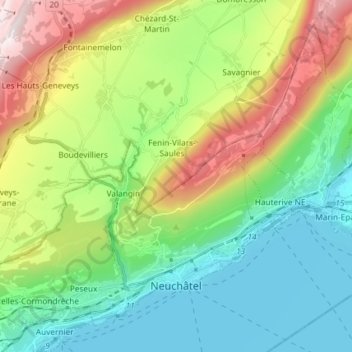
Name: Neuchâtel topographic map, elevation, terrain.

Location: Neuchâtel, Switzerland (46.97784 6.84515 47.06382 6.99178)

Average elevation: 722 m

Minimum elevation: 422 m

Maximum elevation: 1,359 m

Other topographic maps

Click on a map to view its topography, its elevation and its terrain.

Noiraigue

Switzerland > Neuchâtel > Val-de-Travers

Average elevation: 981 m

Môtiers NE

Switzerland > Neuchâtel > Val-de-Travers

Average elevation: 886 m

Noiraigue

Switzerland > Neuchâtel > Val-de-Travers

Average elevation: 981 m

La Roche

Switzerland > Neuchâtel > La Sagne > La Roche

Average elevation: 1,115 m

Marmoud

Switzerland > Neuchâtel > La Sagne

Average elevation: 1,166 m

Gear up for your next adventure:

🧊Portable Cooler - Keep food and drinks cold during outdoor adventures
🧥Softshell Hiking Jacket - The perfect balance of wind protection and breathability
🧥Ultralight Puffy Jacket - Maximum warmth that packs down to the size of an orange
🥾Waterproof Hiking Boots - Essential footwear for rugged terrain and wet Canadian trails
🧥Waterproof Jacket - Lightweight rain jackets for hiking and outdoor activities

As an Amazon Associate, this site earns from qualifying purchases at no extra cost to you.