Geolocate

Chizhou topographic map

Click on the map to display elevation.

About this map

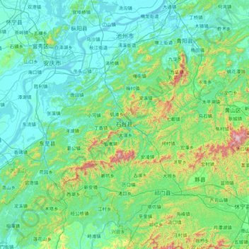
Name: Chizhou topographic map, elevation, terrain.

Location: Chizhou, Anhui, China (29.56507 116.64407 30.84597 118.12954)

Average elevation: 216 m

Minimum elevation: 1 m

Maximum elevation: 1,777 m

Other topographic maps

Click on a map to view its topography, its elevation and its terrain.

Yingjiang

China > Anhui

Average elevation: 34 m

Sucun

China > Anhui > Huangshan City

Average elevation: 266 m

Ningguo

China > Anhui > Ningguo > Xijin Subdistrict

Average elevation: 158 m

Guangde

China > Anhui > Guangde > 桐汭街道

Average elevation: 96 m

Gear up for your next adventure:

💧Hydration Pack - Hands-free hydration system for long hikes
🏃Hydration Running Vest - Carry water and maps close to your body for speed
🧥Softshell Jacket - Windproof and breathable jacket for hiking
🧭GPS Handheld Device - Reliable GPS navigation for outdoor adventures
🧦Outdoor Socks - Durable socks designed for hiking and outdoor sports

As an Amazon Associate, this site earns from qualifying purchases at no extra cost to you.