Geolocate

Bargara topographic map

Click on the map to display elevation.

About this map

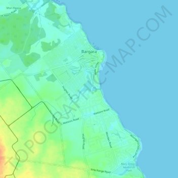
Name: Bargara topographic map, elevation, terrain.

Location: Bargara, Bundaberg Region, Queensland, 4670, Australia (-24.85122 152.44226 -24.80107 152.48075)

Average elevation: 8 m

Minimum elevation: 0 m

Maximum elevation: 36 m

Other topographic maps

Click on a map to view its topography, its elevation and its terrain.

Gin Gin

Australia > Queensland > Bundaberg Region > Gin Gin

Average elevation: 73 m

Isis River

Australia > Queensland > Bundaberg Region > Buxton

Average elevation: 12 m

Burrum River

Australia > Queensland > Bundaberg Region > Buxton

Average elevation: 20 m

Bundaberg

Australia > Queensland > Bundaberg Region

Average elevation: 18 m

Bundaberg

Australia > Queensland > Bundaberg Region

Average elevation: 18 m

Gear up for your next adventure:

❄️Traction Ice Cleats - Slip-on spikes for icy trails and winter hiking
Camping Groundsheet - Protect your tent from moisture and dirt
🌬️Windproof Camp Stove - Efficient cooking even on exposed mountain peaks
🧥Softshell Hiking Jacket - The perfect balance of wind protection and breathability
🌡️Emergency Mylar Blankets - Compact thermal protection for unexpected nights outdoors

As an Amazon Associate, this site earns from qualifying purchases at no extra cost to you.