
Matawatchan topographic map
Interactive map
Click on the map to display elevation.
About this map
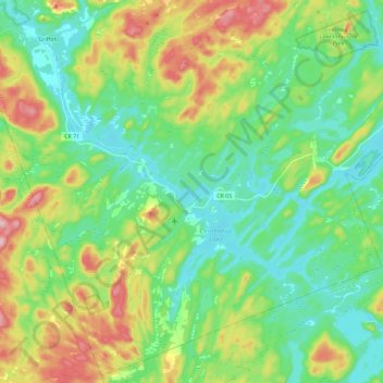
Name: Matawatchan topographic map, elevation, terrain.
Average elevation: 309 m
Minimum elevation: 244 m
Maximum elevation: 449 m
Other topographic maps
Click on a map to view its topography, its elevation and its terrain.
Black Donald Lake
Canada > Ontario > Renfrew County > Greater Madawaska
Black Donald Lake, Greater Madawaska, Renfrew County, Eastern Ontario, Ontario, Canada
Average elevation: 275 m
Jeffers Lake
Canada > Ontario > Renfrew County > Greater Madawaska
Jeffers Lake, Greater Madawaska, Renfrew County, Eastern Ontario, Ontario, Canada
Average elevation: 381 m
Calabogie
Canada > Ontario > Renfrew County > Greater Madawaska
Calabogie, Greater Madawaska, Renfrew County, Eastern Ontario, Ontario, K0J 1H0, Canada
Average elevation: 163 m
St. Pierre Lake
Canada > Ontario > Renfrew County > Greater Madawaska
St. Pierre Lake, Greater Madawaska, Renfrew County, Eastern Ontario, Ontario, Canada
Average elevation: 239 m
Calabogie Lake
Canada > Ontario > Renfrew County > Greater Madawaska > Calabogie
Calabogie Lake, Calabogie, Greater Madawaska, Renfrew County, Eastern Ontario, Ontario, Canada
Average elevation: 181 m
Brule Lake
Canada > Ontario > Renfrew County > Greater Madawaska
Brule Lake, Greater Madawaska, Renfrew County, Eastern Ontario, Ontario, Canada
Average elevation: 351 m
Madawaska River
Canada > Ontario > Renfrew County > Greater Madawaska > Calabogie
Madawaska River, Calabogie, Greater Madawaska, Renfrew County, Eastern Ontario, Ontario, K0J 1H0, Canada
Average elevation: 160 m
Oak Hills
Canada > Ontario > Renfrew County > Greater Madawaska
Oak Hills, Greater Madawaska, Renfrew County, Eastern Ontario, Ontario, Canada
Average elevation: 319 m
Hurds Lake
Canada > Ontario > Renfrew County > Greater Madawaska
Hurds Lake, Greater Madawaska, Renfrew County, Eastern Ontario, Ontario, Canada
Average elevation: 194 m
Griffith
Canada > Ontario > Renfrew County > Greater Madawaska
Griffith, Greater Madawaska, Renfrew County, Eastern Ontario, Ontario, Canada
Average elevation: 292 m
Mount St. Patrick Mountains
Canada > Ontario > Renfrew County > Greater Madawaska
Mount St. Patrick Mountains, Greater Madawaska, Renfrew County, Eastern Ontario, Ontario, Canada
Average elevation: 390 m
Pike Lake
Canada > Ontario > Renfrew County > Greater Madawaska
Pike Lake, Greater Madawaska, Renfrew County, Eastern Ontario, Ontario, Canada
Average elevation: 211 m
Norway Lake
Canada > Ontario > Renfrew County > Greater Madawaska
Norway Lake, Greater Madawaska, Renfrew County, Eastern Ontario, Ontario, Canada
Average elevation: 169 m
Green Lake
Canada > Ontario > Renfrew County > Greater Madawaska
Green Lake, Greater Madawaska, Renfrew County, Eastern Ontario, Ontario, Canada
Average elevation: 294 m
Manitou Lake
Canada > Ontario > Renfrew County > Greater Madawaska
Manitou Lake, Greater Madawaska, Renfrew County, Eastern Ontario, Ontario, Canada
Average elevation: 270 m
Eagles Nest Lookout
Canada > Ontario > Renfrew County > Greater Madawaska
Eagles Nest Lookout, Approach to Calabogie Boulders, Greater Madawaska, Renfrew County, Eastern Ontario, Ontario, Canada
Average elevation: 246 m
Dacre
Canada > Ontario > Renfrew County > Greater Madawaska
Dacre, Greater Madawaska, Renfrew County, Eastern Ontario, Ontario, K0J 1N0, Canada
Average elevation: 217 m