Geolocate

Pike Lake topographic map

Click on the map to display elevation.

About this map

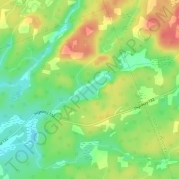
Name: Pike Lake topographic map, elevation, terrain.

Location: Pike Lake, Greater Madawaska, Renfrew County, Eastern Ontario, Ontario, Canada (45.37233 -76.91490 45.37641 -76.90549)

Average elevation: 211 m

Minimum elevation: 184 m

Maximum elevation: 240 m

Renfrew County trails, hiking, mountain biking, running and outdoor activities

Other topographic maps

Click on a map to view its topography, its elevation and its terrain.

Calabogie

Canada > Ontario > Renfrew County > Greater Madawaska

Average elevation: 163 m

Griffith

Canada > Ontario > Renfrew County > Greater Madawaska

Average elevation: 292 m

Norway Lake

Canada > Ontario > Renfrew County > Greater Madawaska

Average elevation: 169 m

Hurds Lake

Canada > Ontario > Renfrew County > Greater Madawaska

Average elevation: 194 m

Oak Hills

Canada > Ontario > Renfrew County > Greater Madawaska

Average elevation: 319 m

Gear up for your next adventure:

🔥Camping Stove - Portable stoves to cook outdoors with ease
🛶Kayak Accessories - Essential gear for safe and fun kayaking adventures
🧰Survival Kit - Essential gear for emergencies in the wilderness
🥘Camping Cookware Set - Compact nesting pots and pans for trail cooking
🧣Evaporative Cooling Towel - Beat the heat during intense summer climbs

As an Amazon Associate, this site earns from qualifying purchases at no extra cost to you.