Geolocate

Étang de la Mer Rouge topographic map

Click on the map to display elevation.

About this map
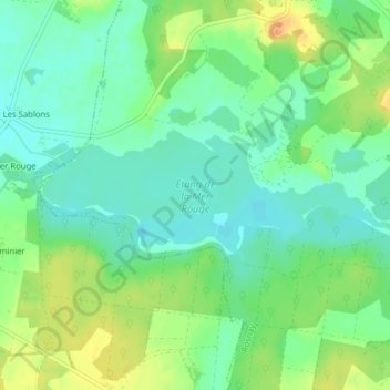
Name: Étang de la Mer Rouge topographic map, elevation, terrain.

Location: Étang de la Mer Rouge, Rosnay, Le Blanc, Indre, Centre-Val de Loire, France métropolitaine, 36300, France (46.70256 1.14897 46.71186 1.18811)

Average elevation: 104 m

Minimum elevation: 90 m

Maximum elevation: 126 m

Other topographic maps

Click on a map to view its topography, its elevation and its terrain.
Le Bouchet

France > Centre-Val de Loire > Indre > Rosnay

Average elevation: 101 m

Le Blizon

France > Centre-Val de Loire > Indre > Rosnay

Average elevation: 98 m

Château du Bouchet

France > Centre-Val de Loire > Indre > Rosnay

Average elevation: 103 m

La Chamborderie

France > Centre-Val de Loire > Indre > Rosnay

Average elevation: 99 m

Gear up for your next adventure:

🔦UV Flashlight - Detect minerals or specific insects in the dark
🧦Hiking Liner Socks - Thin base layer to prevent friction and blisters
🥾Hiking Gaiters - Protect legs and shoes from mud, snow, and debris
🥾Mountain Hiking Boots - High-traction boots for rocky terrain
⛺Family Camping Tent - Spacious tent suitable for family camping trips

As an Amazon Associate, this site earns from qualifying purchases at no extra cost to you.