
Miraflores topographic map
Interactive map
Click on the map to display elevation.
About this map
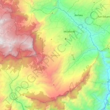
Name: Miraflores topographic map, elevation, terrain.
Location: Miraflores, Lengupá, Boyacá, RAP (Especial) Central, Colombie (5.06299 -73.29589 5.24022 -73.09001)
Average elevation: 1,943 m
Minimum elevation: 823 m
Maximum elevation: 3,345 m
Other topographic maps
Click on a map to view its topography, its elevation and its terrain.
Villa de Leyva
Villa de Leyva, Ricaurte, Boyacá, RAP (Especial) Central, Colombie
Average elevation: 2,416 m
Villa de Leyva
Colombie > Boyacá > Villa de Leyva
Villa de Leyva, Boyacá, 15401, Colombie
Average elevation: 2,673 m