Geolocate

Emmen topographic map

Click on the map to display elevation.

About this map

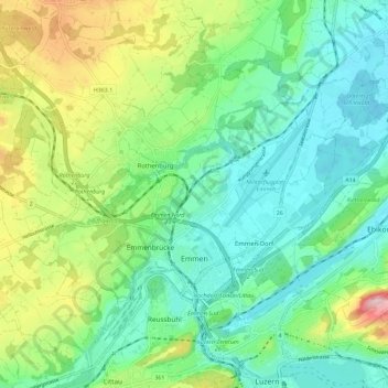
Name: Emmen topographic map, elevation, terrain.

Location: Emmen, Lucerne, Switzerland (47.06480 8.22371 47.11165 8.33835)

Average elevation: 488 m

Minimum elevation: 411 m

Maximum elevation: 673 m

Other topographic maps

Click on a map to view its topography, its elevation and its terrain.

Hellbühl

Switzerland > Lucerne

Average elevation: 639 m

Marbachegg

Switzerland > Lucerne > Escholzmatt-Marbach

Average elevation: 1,159 m

Gunzwil

Switzerland > Lucerne

Average elevation: 671 m

Schiltalp

Switzerland > Lucerne > Kriens

Average elevation: 962 m

Alpach

Switzerland > Lucerne > Escholzmatt-Marbach > Escholzmatt

Average elevation: 966 m

Sörenberg

Switzerland > Lucerne

Average elevation: 1,386 m

Schloss Meggenhorn

Switzerland > Lucerne > Meggen

Average elevation: 450 m

Allmendhubel

Switzerland > Lucerne > Menznau

Average elevation: 636 m

Schachen

Switzerland > Lucerne > Werthenstein > Schachen

Average elevation: 671 m

Gear up for your next adventure:

🧥Thermal Fleece Jacket - Versatile insulation for changing mountain temperatures
🚑Survival Whistle - Signal for help across long distances in mountains
🚲Heavy Duty Bike Lock - Secure your bike at the trailhead or during stops
🦶Hiking Shoe Insoles - Added support for high arches and long days on feet
🕶️Polarized Sunglasses - Reduces glare from snow and water at high elevations

As an Amazon Associate, this site earns from qualifying purchases at no extra cost to you.