
Monroe County topographic map
Interactive map
Click on the map to display elevation.
About this map
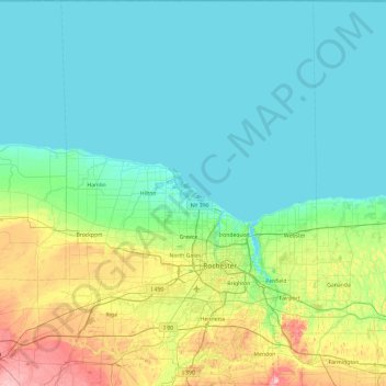
Name: Monroe County topographic map, elevation, terrain.
Location: Monroe County, New York, United States (42.93991 -78.00899 43.63475 -77.37128)
Average elevation: 122 m
Minimum elevation: 72 m
Maximum elevation: 339 m
Other topographic maps
Click on a map to view its topography, its elevation and its terrain.
Manhattan
United States > New York > New York County > New York
Manhattan, New York County, New York, United States
Average elevation: 16 m
Dutchess County
Dutchess County, New York, United States
Average elevation: 179 m
Adirondack Park
Adirondack Park, New York, United States
Average elevation: 371 m
Brooklyn
United States > New York > New York
Brooklyn, Kings County, New York, United States
Average elevation: 9 m
City of Syracuse
United States > New York > Onondaga County
City of Syracuse, Onondaga County, New York, United States
Average elevation: 172 m
Bush Terminal Park
United States > New York > New York
Bush Terminal Park, Brooklyn, Kings County, New York, United States
Average elevation: 8 m
Town of Huntington
United States > New York > Suffolk County
Town of Huntington, Suffolk County, New York, United States
Average elevation: 30 m
Finger Lakes National Forest
United States > New York > Schuyler County > Town of Hector
Finger Lakes National Forest, Town of Hector, Schuyler County, New York, 14818, United States
Average elevation: 356 m
Westchester County
Westchester County, New York, United States
Average elevation: 95 m
Village of Tuckahoe
United States > New York > Westchester County > Town of Eastchester
Village of Tuckahoe, Town of Eastchester, Westchester County, New York, United States
Average elevation: 57 m
City of Schenectady
United States > New York > Schenectady County
City of Schenectady, Schenectady County, New York, 12345, United States
Average elevation: 100 m
Rensselaer County
Rensselaer County, New York, United States
Average elevation: 239 m
Buffalo
United States > New York > Erie County
Buffalo, Erie County, New York, United States
Average elevation: 185 m
City of Ithaca
United States > New York > Tompkins County
City of Ithaca, Tompkins County, New York, United States
Average elevation: 195 m
City of Binghamton
United States > New York > Broome County
City of Binghamton, Dickinson, Broome County, New York, 13905, United States
Average elevation: 321 m
The Bronx
United States > New York > New York
The Bronx, New York, United States
Average elevation: 23 m
Saratoga County
Saratoga County, New York, United States
Average elevation: 218 m
East Hampton
United States > New York > Suffolk County > East Hampton > Village of East Hampton
East Hampton, Village of East Hampton, Suffolk County, New York, 11937, United States
Average elevation: 12 m
Montauk
United States > New York > Suffolk County > Town of East Hampton
Montauk, Town of East Hampton, Suffolk County, New York, 11954, United States
Average elevation: 2 m
City of Rye
United States > New York > Westchester County
City of Rye, Westchester County, New York, United States
Average elevation: 9 m
City of Yonkers
United States > New York > Westchester County
City of Yonkers, Westchester County, New York, United States
Average elevation: 58 m
Cortland County
Cortland County, New York, United States
Average elevation: 453 m
Upper West Side
United States > New York > New York
Upper West Side, Manhattan Community Board 7, Manhattan, New York County, New York, United States
Average elevation: 23 m
Tompkins County
Tompkins County, New York, United States
Average elevation: 377 m
Columbia County
Columbia County, New York, United States
Average elevation: 196 m
Central Park
United States > New York > New York County > New York
Central Park, New York County, New York, United States
Average elevation: 26 m
Roosevelt Island
United States > New York > New York County > New York
Roosevelt Island, Manhattan, New York County, New York, 10044, United States
Average elevation: 13 m
Millsite Lake
United States > New York > Jefferson County > Town of Theresa
Millsite Lake, Town of Theresa, Jefferson County, New York, United States
Average elevation: 107 m
Village of Otego
United States > New York > Otsego County
Village of Otego, Town of Otego, Otsego County, New York, United States
Average elevation: 364 m
Saratoga Springs
United States > New York > Saratoga County > Saratoga Springs
Saratoga Springs, City of Saratoga Springs, Saratoga County, New York, 12866, United States
Average elevation: 161 m
Village of Scarsdale
United States > New York > Westchester County
Village of Scarsdale, Westchester County, New York, 10583, United States
Average elevation: 76 m
Lake George
United States > New York > Warren County > Town of Bolton
Lake George, Town of Bolton, Warren County, New York, United States
Average elevation: 247 m
Manhattan Island
United States > New York > New York
Manhattan Island, New York, United States
Average elevation: 17 m
Troy
United States > New York > Rensselaer County
Troy, Rensselaer County, New York, 12181, United States
Average elevation: 137 m
Staten Island
United States > New York > New York
Staten Island, Richmond County, New York, United States
Average elevation: 9 m
Town of Vestal
United States > New York > Broome County
Town of Vestal, Broome County, New York, United States
Average elevation: 372 m
City of Troy
United States > New York > Rensselaer County
City of Troy, Rensselaer County, New York, United States
Average elevation: 81 m
Petrolia
United States > New York > Allegany County
Petrolia, Town of Scio, Allegany County, New York, 14707, United States
Average elevation: 624 m
Town of Sangerfield
United States > New York > Oneida County
Town of Sangerfield, Oneida County, New York, United States
Average elevation: 436 m
Godeffroy
United States > New York > Orange County
Godeffroy, Town of Deerpark, Orange County, New York, 12739, United States
Average elevation: 215 m
Town of Shelter Island
United States > New York > Suffolk County
Town of Shelter Island, Suffolk County, New York, United States
Average elevation: 3 m
City of Plattsburgh
United States > New York > Clinton County
City of Plattsburgh, Clinton County, New York, United States
Average elevation: 50 m