

Make a donation
Gear up for your next adventure:
As an Amazon Associate, this site earns from qualifying purchases at no extra cost to you.
The Bronx topographic map
Click on the map to display elevation.
Make a donation
Gear up for your next adventure:
As an Amazon Associate, this site earns from qualifying purchases at no extra cost to you.
The Bronx
The Bronx's highest elevation at 280 feet (85 m) is in the northwest corner, west of Van Cortlandt Park and in the Chapel Farm area near the Riverdale Country School. The opposite (southeastern) side of the Bronx has four large low peninsulas or "necks" of low-lying land that jut into the waters of the East River and were once salt marsh: Hunt's Point, Clason's Point, Screvin's Neck and Throggs Neck. Further up the coastline, Rodman's Neck lies between Pelham Bay Park in the northeast and City Island. The Bronx's irregular shoreline extends for 75 square miles (194 km2).
Make a donation
Gear up for your next adventure:
As an Amazon Associate, this site earns from qualifying purchases at no extra cost to you.
About this map
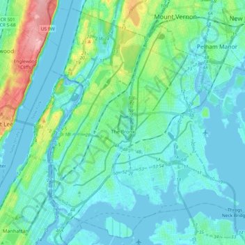
Name: The Bronx topographic map, elevation, terrain.
Location: The Bronx, Bronx County, New York, United States (40.78574 -73.93391 40.91763 -73.74837)
Average elevation: 23 m
Minimum elevation: -9 m
Maximum elevation: 139 m
Make a donation
Gear up for your next adventure:
As an Amazon Associate, this site earns from qualifying purchases at no extra cost to you.
Other topographic maps
Click on a map to view its topography, its elevation and its terrain.
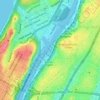
Roberto Clemente State Park
United States > New York > Bronx County > New York
Average elevation: 32 m
Make a donation
Gear up for your next adventure:
As an Amazon Associate, this site earns from qualifying purchases at no extra cost to you.