
Elverum topographic map
Interactive map
Click on the map to display elevation.
About this map
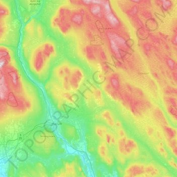
Name: Elverum topographic map, elevation, terrain.
Location: Elverum, Innlandet, Norway (60.74126 11.29895 61.20427 12.16109)
Average elevation: 407 m
Minimum elevation: 153 m
Maximum elevation: 846 m
Other topographic maps
Click on a map to view its topography, its elevation and its terrain.
Li
Norway > Innlandet > Skammestein
Li, Skammestein, Øystre Slidre, Innlandet, 2950, Norway
Average elevation: 774 m
Scandinavian Mountains
Scandinavian Mountains, Lom, Innlandet, Norway
Average elevation: 2,050 m
Fregn naturreservat
Fregn naturreservat, Trysil, Innlandet, Norway
Average elevation: 673 m
Viewpoint Snøhetta
Viewpoint Snøhetta, Vålåsjøhøvegen, Dovre, Innlandet, 2661, Norway
Average elevation: 1,157 m
Beitostølen
Beitostølen, Øystre Slidre, Innlandet, 2953, Norway
Average elevation: 914 m