Geolocate

Hafjell topographic map

Click on the map to display elevation.

About this map

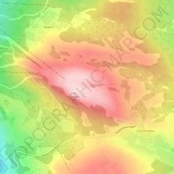
Name: Hafjell topographic map, elevation, terrain.

Location: Hafjell, Nysætra, Øyer, Innlandet, Norway (61.22734 10.51732 61.23390 10.53973)

Average elevation: 964 m

Minimum elevation: 816 m

Maximum elevation: 1,068 m

Gear up for your next adventure:

🛶Kayak Dry Bag - Waterproof storage for kayaking adventures
🧰Multitool Knife - Compact and versatile tool for outdoor use
🧦Merino Wool Socks - Moisture-wicking comfort for long-distance hiking
Lightweight Backpacking Tent - Compact tent for efficient hiking trips
🩹Moleskin Blister Pads - Direct protection for painful foot pressure points

As an Amazon Associate, this site earns from qualifying purchases at no extra cost to you.