
Make a donation
Gear up for your next adventure:
As an Amazon Associate, this site earns from qualifying purchases at no extra cost to you.
Sulphur Springs topographic map
Click on the map to display elevation.
Make a donation
Gear up for your next adventure:
As an Amazon Associate, this site earns from qualifying purchases at no extra cost to you.
About this map
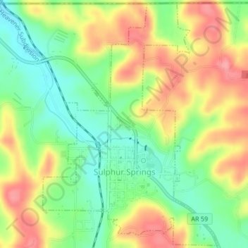
Name: Sulphur Springs topographic map, elevation, terrain.
Location: Sulphur Springs, Benton County, Arkansas, United States (36.47299 -94.47098 36.49937 -94.44727)
Average elevation: 308 m
Minimum elevation: 263 m
Maximum elevation: 357 m
Make a donation
Gear up for your next adventure:
As an Amazon Associate, this site earns from qualifying purchases at no extra cost to you.
Other topographic maps
Click on a map to view its topography, its elevation and its terrain.
Make a donation
Gear up for your next adventure:
As an Amazon Associate, this site earns from qualifying purchases at no extra cost to you.
Siloam Springs Lake
United States > Arkansas > Benton County > Siloam Springs
Average elevation: 341 m
Make a donation
Gear up for your next adventure:
As an Amazon Associate, this site earns from qualifying purchases at no extra cost to you.
Benton Country Fair Grounds
United States > Arkansas > Benton County > Bentonville
Average elevation: 384 m
Bella Vista
United States > Arkansas > Benton County > Bella Vista > Bella Vista
Average elevation: 359 m
Make a donation
Gear up for your next adventure:
As an Amazon Associate, this site earns from qualifying purchases at no extra cost to you.
Make a donation
Gear up for your next adventure:
As an Amazon Associate, this site earns from qualifying purchases at no extra cost to you.