Geolocate

Bahadurpur topographic map

Click on the map to display elevation.

About this map
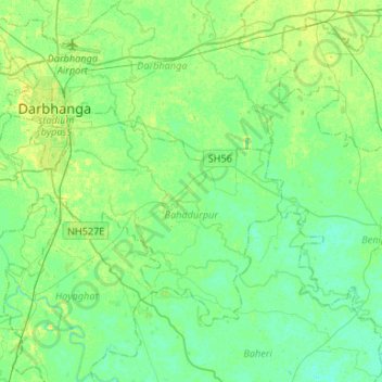
Name: Bahadurpur topographic map, elevation, terrain.

Location: Bahadurpur, Darbhanga, Bihar, India (26.02142 85.79391 26.18962 86.05831)

Average elevation: 48 m

Minimum elevation: 42 m

Maximum elevation: 58 m

Other topographic maps

Click on a map to view its topography, its elevation and its terrain.
Danapur

India > Bihar > Dinapur-Cum-Khagaul

Average elevation: 52 m

Kishanpur

India > Bihar > Kishanpur

Average elevation: 55 m

Kuari

India > Bihar > Dhamdaha

Average elevation: 37 m

Rusera

India > Bihar > Rosera

Average elevation: 45 m

Singheswar

India > Bihar > Singheshwar

Average elevation: 47 m

Runisaidpur

India > Bihar > Runisaidpur

Average elevation: 58 m

Maheshkhunt

India > Bihar > Gogri

Average elevation: 36 m

Gear up for your next adventure:

🔥Emergency Fire Starter - Reliable ignition source for all weather conditions
💧Hydration Pack - Hands-free hydration system for long hikes
🧭GPS Tracker - Track your location in remote areas safely
👖Convertible Hiking Pants - Zip-off legs to adapt to changing weather conditions
❄️Traction Ice Cleats - Slip-on spikes for icy trails and winter hiking

As an Amazon Associate, this site earns from qualifying purchases at no extra cost to you.