Geolocate

Greenhithe topographic map

Click on the map to display elevation.

About this map

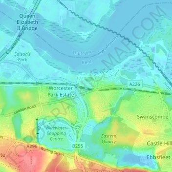
Name: Greenhithe topographic map, elevation, terrain.

Location: Greenhithe, Dartford, Kent, England, DA9 9QR, United Kingdom (51.43074 0.26176 51.47074 0.30176)

Average elevation: 18 m

Minimum elevation: -7 m

Maximum elevation: 80 m

Other topographic maps

Click on a map to view its topography, its elevation and its terrain.

Wilmington

United Kingdom > England > Kent > Dartford > Wilmington

Average elevation: 47 m

Craylands Gorge

United Kingdom > England > Kent > Dartford > Swanscombe

Average elevation: 19 m

Bean

United Kingdom > England > Kent > Dartford > Bean

Average elevation: 52 m

Dartford Marshes

United Kingdom > England > Kent > Dartford

Average elevation: 4 m

Darenth

United Kingdom > England > Kent > Dartford > Darenth

Average elevation: 40 m

Wilmington

United Kingdom > England > Kent > Dartford > Wilmington

Average elevation: 47 m

Gear up for your next adventure:

🧴Outdoor Sunscreen - High SPF protection for high-altitude UV exposure
👖Convertible Hiking Pants - Zip-off legs to adapt to changing weather conditions
🥾Trail Running Boots - Durable shoes designed for trail running
🔥Camping Stove - Portable stoves to cook outdoors with ease
🧭Orienteering Kit - Tools for map reading and navigation in the wild

As an Amazon Associate, this site earns from qualifying purchases at no extra cost to you.