Geolocate

Wilmington topographic map

Click on the map to display elevation.

About this map

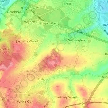
Name: Wilmington topographic map, elevation, terrain.

Location: Wilmington, Dartford, Kent, England, United Kingdom (51.40680 0.15818 51.43670 0.22600)

Average elevation: 47 m

Minimum elevation: 5 m

Maximum elevation: 83 m

Gear up for your next adventure:

🥾Mountain Trail Shoes - High-traction shoes for mountain trails
🏃Hydration Running Vest - Carry water and maps close to your body for speed
🧢Hiking Hat - Sun-protective and breathable hats for long treks
🧦Hiking Liner Socks - Thin base layer to prevent friction and blisters
👟Trail Running Shoes - Agile footwear for fast-paced topographic exploration

As an Amazon Associate, this site earns from qualifying purchases at no extra cost to you.