
Make a donation
Gear up for your next adventure:
As an Amazon Associate, this site earns from qualifying purchases at no extra cost to you.
Ilocos Region topographic map
Click on the map to display elevation.
Make a donation
Gear up for your next adventure:
As an Amazon Associate, this site earns from qualifying purchases at no extra cost to you.
Ilocos Region
The southern parts of the region were severely hit by the 1990 Luzon earthquake. Five municipalities in La Union were affected: Agoo, Aringay, Caba, Santo Tomas, and Tubao with a combined population of 132,208. Many buildings, including the Agoo Municipal hall, the Museo de Iloko, the parish church of Aringay, and the Basilica Minore of our Lady of Charity, collapsed or were severely damaged. Sitio Nagpanauan in Aringay completely submerged when the sea level rose and the land collapsed during the earthquake. 100,000 families were displaced when two coastal villages sank due to liquefaction. The province suffered many casualties leaving 32 people dead. In Pangasinan, about 90 buildings in Dagupan were damaged, and about 20 collapsed. Some structures sustained damage because liquefaction caused buildings to sink as much as 1 metre (39 inches). The earthquake caused a decrease in the elevation of the city and several areas were flooded. The city suffered 64 casualties of which 47 survived and 17 died. Most injuries were sustained during stampedes at a university building and a theater.
Make a donation
Gear up for your next adventure:
As an Amazon Associate, this site earns from qualifying purchases at no extra cost to you.
About this map
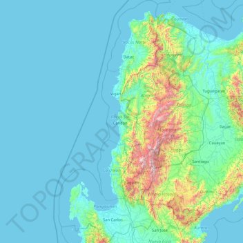
Name: Ilocos Region topographic map, elevation, terrain.
Location: Ilocos Region, Philippines (15.61864 119.60779 18.79030 120.97938)
Average elevation: 219 m
Minimum elevation: -1 m
Maximum elevation: 2,751 m
Make a donation
Gear up for your next adventure:
As an Amazon Associate, this site earns from qualifying purchases at no extra cost to you.
Other topographic maps
Click on a map to view its topography, its elevation and its terrain.
Quezon City
Founded as a pueblo by Saint Pedro Bautista in 1590, San Francisco del Monte may be considered Quezon City's oldest district. The original land area of the old town of San Francisco del Monte was approximately2.5 square kilometres (1.0 sq mi) and covered parts of what is currently known as Project 7 and 8 and…
Average elevation: 57 m
Make a donation
Gear up for your next adventure:
As an Amazon Associate, this site earns from qualifying purchases at no extra cost to you.
Antipolo
Its higher elevation than that of Metro Manila affords it a scenic view of the metropolis, especially at night. Its locally grown mangoes and cashews are popular among tourists, as well as suman – a local delicacy made out of glutinous rice. The Hinulugang Taktak National Park, which was once a popular…
Average elevation: 125 m
Make a donation
Gear up for your next adventure:
As an Amazon Associate, this site earns from qualifying purchases at no extra cost to you.
Janiuay
Santo Tomas approximate population is 500–800. Santo Tomas (Pakol to locals) is bounded by Madong in the east, Mangil in the north-east and Danao in the south west. It is accessible by three class C feeder roads in the east, south-west and south-east. Agriculture centers around rice, corn, coffee, beans,…
Average elevation: 82 m
Buhi
Buhi has generally mountainous and hilly surface, with 50% of its area having a slope of around 25%. The Poblacion located on the south shore of Lake Buhi, has gently rolling topography.
Average elevation: 161 m
Make a donation
Gear up for your next adventure:
As an Amazon Associate, this site earns from qualifying purchases at no extra cost to you.
Make a donation
Gear up for your next adventure:
As an Amazon Associate, this site earns from qualifying purchases at no extra cost to you.
Montalban
Philippines > Rizal > Rodriguez
Rodriguez is generally very rough in topography, with 83% of its total land area composed of upland areas, hills and mountain ranges. The remaining 17% low-lying terrain and rolling lands are found at the south-western portion of the municipality, along with the northern portions of the Municipality of San…
Average elevation: 99 m
Make a donation
Gear up for your next adventure:
As an Amazon Associate, this site earns from qualifying purchases at no extra cost to you.
Mount Banahaw
Philippines > Quezon > Tayabas
The andesitic Banahaw volcanic complex is composed of several stratovolcanoes with Mount Banahaw, the largest with a maximum elevation of 2,170 metres (7,119 ft) above mean sea level. The summit is topped by a 1.5 by 3.5 kilometres (0.93 mi × 2.17 mi) and 210 metres (690 ft) deep crater that is breached on…
Average elevation: 1,730 m
Malolos
Malolos is relatively flat of about 0.81% to a gently sloping of 2.17%. The slope of the land descends towards west, southwest to southern direction. The highest land elevation is at about 6.0 meters above sea level while the lowest is only half a meter below sea level. A network of natural waterways and…
Average elevation: 6 m
Make a donation
Gear up for your next adventure:
As an Amazon Associate, this site earns from qualifying purchases at no extra cost to you.
Baguio
In 1903, Filipinos, Japanese and Chinese workers were hired to build Kennon Road, the first road directly connecting Baguio with the lowlands of La Union and Pangasinan. Before this, the only road to Benguet was Naguilian Road, and it was largely a horse trail at higher elevations. Camp John Hay was…
Average elevation: 881 m
Make a donation
Gear up for your next adventure:
As an Amazon Associate, this site earns from qualifying purchases at no extra cost to you.
Make a donation
Gear up for your next adventure:
As an Amazon Associate, this site earns from qualifying purchases at no extra cost to you.
Make a donation
Gear up for your next adventure:
As an Amazon Associate, this site earns from qualifying purchases at no extra cost to you.
Make a donation
Gear up for your next adventure:
As an Amazon Associate, this site earns from qualifying purchases at no extra cost to you.
Mandaue
It is one of the two (the other one being the municipality of Consolacion) local government units located within the mainland Metro Cebu where the elevation of land is less than 100 m (330 ft).
Average elevation: 109 m
Trece Martires
The city of Trece Martires is characterised with ground elevation ranging from 30m to nearly 400m. Its ground slope ranges from 0.5 to 2%.
Average elevation: 150 m
Daraga
67.3% of the total municipal land area has a predominantly low elevation of up to 100 metres (330 ft). The surface terrain is generally characterized by combination of level to nearly level areas, gentle to undulating areas and undulating to rolling areas.
Average elevation: 76 m
Make a donation
Gear up for your next adventure:
As an Amazon Associate, this site earns from qualifying purchases at no extra cost to you.
San Juan
"San Juan" is a contraction of the city's traditional name of "San Juan del Monte" (lit. 'Saint John of the Mountain'). As with numerous other places in the Philippines, the name combines a patron saint and a toponym; in this case Saint John the Baptist with the locale's hilly terrain and relatively higher…
Average elevation: 35 m
Make a donation
Gear up for your next adventure:
As an Amazon Associate, this site earns from qualifying purchases at no extra cost to you.
San Juan
The topography of the town is characterized by hilly and mountainous terrain that gradually rises eastward from its coastal plains along the foothills of the Cordillera Central. The town is also traversed by several creeks and rivers, with the Baroro River being the most prominent.
Average elevation: 21 m
Make a donation
Gear up for your next adventure:
As an Amazon Associate, this site earns from qualifying purchases at no extra cost to you.
Make a donation
Gear up for your next adventure:
As an Amazon Associate, this site earns from qualifying purchases at no extra cost to you.
Legazpi
Legazpi's topography is generally plain on the northeastern areas, with slopes ranging from five to fifteen degrees. The southern areas have mostly rolling to hilly terrain. In the city's coastal areas, the terrain varies from plain (north) to hilly (south). Legazpi is criss-crossed by several rivers including…
Average elevation: 150 m
Calapan
Philippines > Oriental Mindoro
The overall land characteristic is a wide plain with rivers, interspersed with wetlands at the seacoast periphery. The highest elevation is 187 m (614 ft) above sea level at Bulusan Hill, a 6-kilometre (3.7 mi) long landform east of the city, which interrupts the mostly flat terrain north-east of the…
Average elevation: 40 m
Make a donation
Gear up for your next adventure:
As an Amazon Associate, this site earns from qualifying purchases at no extra cost to you.
San Jose
The city of San Jose lies at 15° 47' North, 120° 59' East in Central Luzon. The estimated elevation at these coordinates is approximately 109.9 meters or 360.4 feet above mean sea level.
Average elevation: 175 m
Tuba
Tuba's topography is generally characterized by irregular rugged terrain and steep slopes with several mountain peaks rising from the table land itself. Mount Santo Tomas, the highest peak in the municipality soars to 2,252 metres (7,388 ft) above sea level.
Average elevation: 1,242 m
Make a donation
Gear up for your next adventure:
As an Amazon Associate, this site earns from qualifying purchases at no extra cost to you.
Make a donation
Gear up for your next adventure:
As an Amazon Associate, this site earns from qualifying purchases at no extra cost to you.
Tagaytay
The southern and eastern portions of Tagaytay are covered by hills and mountains which is generally forests, pine trees and open grasslands. The city lies along Tagaytay Ridge, a ridge stretching about 32 kilometres (20 mi) from Mount Batulao in the west to Mount Sungay in the east with elevations averaging…
Average elevation: 229 m
Tagum
One of the significant accomplishments of the officialdom of Tagum during the 1990s was its elevation from a second to the first-class municipality. This opened a gateway to increase its financial resources through the Internal Revenue Allocation (IRA) from the national government and local revenues. This was…
Average elevation: 103 m
Make a donation
Gear up for your next adventure:
As an Amazon Associate, this site earns from qualifying purchases at no extra cost to you.
Vigan
Vigan is situated in a Quaternary Age sedimentary plain called the Vigan-Bantay Plain which is part of the Ilocos coastal plain. The Vigan-Bantay Plain is bounded on the east by a moderately rugged Miocene sediments consisting of interbedded sandstones and shale to very rugged Meta-volcanics and Meta sediment…
Average elevation: 63 m
Bacolod
Bacólod (English: Bacolod), is derived from bakólod (Old Spelling: bacólod), the Old Hiligaynon (Old Ilonggo) (Old Spelling: Ylongo and Ilongo) word for a "hill, turtle, mound, rise, hillock, down, any small eminence or elevation", since the resettlement was founded on a stony, hilly area, now the barangay…
Average elevation: 49 m
Mandaluyong
Another claims that the Spaniards named the place based on the report of a navigator named Acapulco, who saw the rolling hills frequently being lashed at by daluyong (“big waves from the sea”). This seems to confirm traditional pre-Hispanic stories that giant waves from the sea would meet the adjoining…
Average elevation: 33 m
Make a donation
Gear up for your next adventure:
As an Amazon Associate, this site earns from qualifying purchases at no extra cost to you.
Make a donation
Gear up for your next adventure:
As an Amazon Associate, this site earns from qualifying purchases at no extra cost to you.
Make a donation
Gear up for your next adventure:
As an Amazon Associate, this site earns from qualifying purchases at no extra cost to you.
Make a donation
Gear up for your next adventure:
As an Amazon Associate, this site earns from qualifying purchases at no extra cost to you.
Make a donation
Gear up for your next adventure:
As an Amazon Associate, this site earns from qualifying purchases at no extra cost to you.
Make a donation
Gear up for your next adventure:
As an Amazon Associate, this site earns from qualifying purchases at no extra cost to you.
Make a donation
Gear up for your next adventure:
As an Amazon Associate, this site earns from qualifying purchases at no extra cost to you.