Geolocate

Cepagatti topographic map

Click on the map to display elevation.

About this map
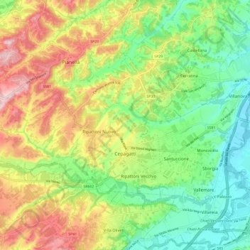
Name: Cepagatti topographic map, elevation, terrain.

Location: Cepagatti, Pescara, Abruzzo, 65012, Italy (42.33091 14.05751 42.41756 14.16182)

Average elevation: 125 m

Minimum elevation: 18 m

Maximum elevation: 277 m

Other topographic maps

Click on a map to view its topography, its elevation and its terrain.

Cugnoli

Italy > Abruzzo > Pescara > Turrivalignani

Average elevation: 203 m

La Maielletta

Italy > Abruzzo > Pescara > Roccamorice

Average elevation: 1,694 m

Pagliari

Italy > Abruzzo > Pescara > Roccamorice

Average elevation: 623 m

11

Italy > Abruzzo > Pescara > Brittoli > Boragne

Average elevation: 603 m

Fonte Tettone

Italy > Abruzzo > Pescara > Roccamorice

Average elevation: 1,507 m

Traino

Italy > Abruzzo > Pescara > Villa Celiera

Average elevation: 917 m

Chianchiro

Italy > Abruzzo > Pescara > Villa Cupoli

Average elevation: 511 m

Vestea

Italy > Abruzzo > Pescara

Average elevation: 540 m

Gear up for your next adventure:

⛺Bushcraft Tarp - Versatile emergency shelter or gear protection
🧦Thermal Socks - Warm socks for winter hiking or camping
🧤Insulated Winter Gloves - Heavy-duty protection for sub-zero Canadian adventures
💧Hydration Pack - Hands-free hydration system for long hikes
🦟Insect Repellent - Keep mosquitoes and black flies away in wooded areas

As an Amazon Associate, this site earns from qualifying purchases at no extra cost to you.