Geolocate

Haxey topographic map

Click on the map to display elevation.

Haxey

The civil parish includes the town of Haxey and the village of Westwoodside, and the hamlets of Haxey Carr, High Burnham (the highest elevation of the Isle of Axholme), Low Burnham, East Lound, Graizelound and Upperthorpe which is conjoined to Westwoodside.

Wikipedia (CC-BY-SA 3.0)

About this map

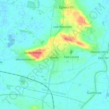
Name: Haxey topographic map, elevation, terrain.

Location: Haxey, North Lincolnshire, South Yorkshire, England, United Kingdom (53.46027 -0.92062 53.52115 -0.78842)

Average elevation: 7 m

Minimum elevation: -4 m

Maximum elevation: 42 m

Other topographic maps

Click on a map to view its topography, its elevation and its terrain.

Cleatham

United Kingdom > England > North Lincolnshire

Average elevation: 36 m

Ealand

United Kingdom > England > North Lincolnshire

Average elevation: 4 m

Crowle

United Kingdom > England > North Lincolnshire

Average elevation: 3 m

Bracon

United Kingdom > England > North Lincolnshire

Average elevation: 7 m

Keadby

United Kingdom > England > North Lincolnshire

Average elevation: 3 m

Beltoft

United Kingdom > England > North Lincolnshire

Average elevation: 5 m

Gear up for your next adventure:

🧣Merino Neck Gaiter - Protects against wind, sun, and cold at high altitudes
Bushcraft Tarp - Versatile emergency shelter or gear protection
🎒Backpack Rain Cover - External shield to keep your entire pack dry
🛌Insulated Sleeping Pad - Critical thermal barrier between you and the cold ground
🛰️Satellite Messenger - Emergency communication for areas with no cell service

As an Amazon Associate, this site earns from qualifying purchases at no extra cost to you.