Geolocate

El Morro topographic map

Click on the map to display elevation.

About this map

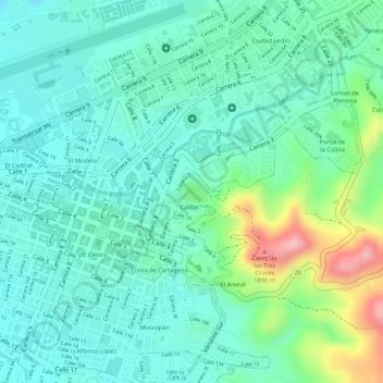
Name: El Morro topographic map, elevation, terrain.

Location: El Morro, Caldas, Popayán, Centro, Cauca, RAP Pacífico, Colombia (2.44396 -76.60106 2.44554 -76.59886)

Average elevation: 1,751 m

Minimum elevation: 1,706 m

Maximum elevation: 1,874 m

Other topographic maps

Click on a map to view its topography, its elevation and its terrain.

Popayán

Colombia > Cauca > Popayán

Popayán,​ oficialmente Asunción de Popayán, es un municipio colombiano, capital del departamento del Cauca. Se encuentra localizado en el valle de Pubenza, entre la Cordillera Occidental y Central al suroccidente del país. Su extensión territorial es de 512 km², su altitud media es de 1760 m sobre el…

Average elevation: 1,990 m

SANTA ROSA

Colombia > Cauca > Popayán

Average elevation: 1,728 m

Pisojé Bajo

Colombia > Cauca > Popayán

Average elevation: 2,136 m

San Rafael

Colombia > Cauca > Popayán

Average elevation: 1,716 m

POBLAZON

Colombia > Cauca > Popayán

Average elevation: 2,230 m

La Meseta

Colombia > Cauca > Popayán

Average elevation: 1,704 m

Vereda de Torres

Colombia > Cauca > Popayán

Average elevation: 1,717 m

Gear up for your next adventure:

🥾Waterproof Hiking Shoes - Durable shoes for wet and rugged trails
🥾Mountain Hiking Shoes - Shoes with superior grip for mountainous terrain
🛶Kayak Dry Bag - Waterproof storage for kayaking adventures
💡LED Headlamp - Hands-free illumination for night hiking and camping
🧊Insulated Water Bottle - Keeps drinks cold in summer and prevents freezing in winter

As an Amazon Associate, this site earns from qualifying purchases at no extra cost to you.