Geolocate

POBLAZON topographic map

Click on the map to display elevation.

About this map

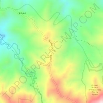
Name: POBLAZON topographic map, elevation, terrain.

Location: POBLAZON, Popayán, Centro, Cauca, Pacífica, Colombia (2.38520 -76.55822 2.40520 -76.53822)

Average elevation: 2,230 m

Minimum elevation: 2,066 m

Maximum elevation: 2,435 m

Other topographic maps

Click on a map to view its topography, its elevation and its terrain.

El Morro

Colombia > Cauca > Popayán

Average elevation: 1,751 m

Resguardo Indígena Quintana

Colombia > Cauca > Popayán

Average elevation: 2,258 m

Gear up for your next adventure:

🧰Survival Kit - Essential gear for emergencies in the wilderness
🧼Biodegradable Camp Soap - Environmentally friendly cleaning for gear and body
💧Reusable Water Bottle - Durable water bottles for hydration on trails
🥘Camping Cookware Set - Compact nesting pots and pans for trail cooking
🥾Trail Running Boots - Durable shoes designed for trail running

As an Amazon Associate, this site earns from qualifying purchases at no extra cost to you.