Geolocate

SANTA ROSA topographic map

Click on the map to display elevation.

About this map

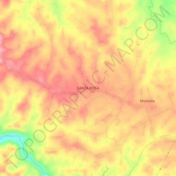
Name: SANTA ROSA topographic map, elevation, terrain.

Location: SANTA ROSA, Popayán, Centro, Cauca, RAP Pacífico, Colombia (2.49553 -76.66606 2.53553 -76.62606)

Average elevation: 1,728 m

Minimum elevation: 1,637 m

Maximum elevation: 1,775 m

Other topographic maps

Click on a map to view its topography, its elevation and its terrain.

El Morro

Colombia > Cauca > Popayán

Average elevation: 1,751 m

Resguardo Indígena Quintana

Colombia > Cauca > Popayán

Average elevation: 2,258 m

Gear up for your next adventure:

🌡️Emergency Mylar Blankets - Compact thermal protection for unexpected nights outdoors
Lightweight Backpacking Tent - Compact tent for efficient hiking trips
🥾Trekking Poles - Adjustable trekking poles to reduce knee stress and improve stability
🧦Hiking Socks - Moisture-wicking and comfortable socks for long hikes
🌬️Windproof Camp Stove - Efficient cooking even on exposed mountain peaks

As an Amazon Associate, this site earns from qualifying purchases at no extra cost to you.