
Make a donation
Gear up for your next adventure:
As an Amazon Associate, this site earns from qualifying purchases at no extra cost to you.
Zederhaus topographic map
Click on the map to display elevation.
Make a donation
Gear up for your next adventure:
As an Amazon Associate, this site earns from qualifying purchases at no extra cost to you.
About this map
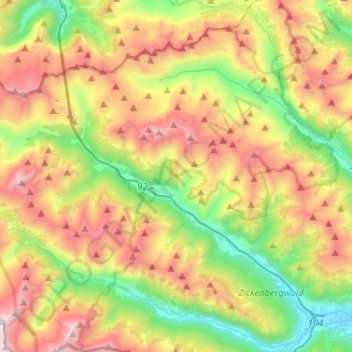
Name: Zederhaus topographic map, elevation, terrain.
Location: Zederhaus, Bezirk Tamsweg, Salzburg, 5584, Österreich (47.11018 13.31780 47.22109 13.57598)
Average elevation: 1,822 m
Minimum elevation: 1,045 m
Maximum elevation: 2,894 m
Make a donation
Gear up for your next adventure:
As an Amazon Associate, this site earns from qualifying purchases at no extra cost to you.
Other topographic maps
Click on a map to view its topography, its elevation and its terrain.
Edenvest
Österreich > Salzburg > Bezirk Tamsweg > Thomatal > Bundschuh
Am linken Ufer des Bundschuhbachs (südlich von Gruben) liegen auf einem heute dicht bewaldeten Felsenkopf die Reste der Burg Edenvest (= „öde Festung“). Die Anlage ist von Norden aus zugänglich. Im Süden und Osten fällt der Felsen etwa 40 Meter senkrecht zum Bundschuhbach ab. Ein Teil der Burganlage…
Average elevation: 1,271 m
Oberbayrdorf
Österreich > Salzburg > Bezirk Tamsweg > Sankt Margarethen im Lungau
Average elevation: 1,212 m
Make a donation
Gear up for your next adventure:
As an Amazon Associate, this site earns from qualifying purchases at no extra cost to you.
St. Michael im Lungau
Österreich > Salzburg > Bezirk Tamsweg > Sankt Michael im Lungau
Average elevation: 1,307 m
Make a donation
Gear up for your next adventure:
As an Amazon Associate, this site earns from qualifying purchases at no extra cost to you.