
Thank you for supporting this site ❤️
Make a donation
Make a donation
Gear up for your next adventure:
As an Amazon Associate, this site earns from qualifying purchases at no extra cost to you.
Judendorf topographic map
Click on the map to display elevation.
Thank you for supporting this site ❤️
Make a donation
Make a donation
Gear up for your next adventure:
As an Amazon Associate, this site earns from qualifying purchases at no extra cost to you.
About this map
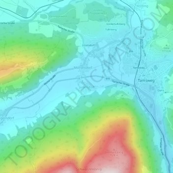
Name: Judendorf topographic map, elevation, terrain.
Location: Judendorf, Tamsweg, Bezirk Tamsweg, Salzburg, 5580, Österreich (47.10461 13.77018 47.14461 13.81018)
Average elevation: 1,144 m
Minimum elevation: 1,001 m
Maximum elevation: 1,598 m
Thank you for supporting this site ❤️
Make a donation
Make a donation
Gear up for your next adventure:
As an Amazon Associate, this site earns from qualifying purchases at no extra cost to you.