Geolocate

Colmar topographic map

Click on the map to display elevation.

About this map

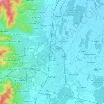
Name: Colmar topographic map, elevation, terrain.

Location: Colmar, Colmar-Ribeauvillé, Haut-Rhin, Grand Est, Metropolitan France, 68000, France (48.04071 7.31548 48.18206 7.46917)

Average elevation: 233 m

Minimum elevation: 174 m

Maximum elevation: 820 m

Other topographic maps

Click on a map to view its topography, its elevation and its terrain.

Ballon d'Alsace

France > Grand Est > Haut-Rhin > Sewen

Average elevation: 994 m

Bingle

France > Grand Est > Haut-Rhin > Eschentzwiller

Average elevation: 274 m

Hohrodberg

France > Grand Est > Haut-Rhin > Hohrod

Average elevation: 696 m

Kutz

France > Grand Est > Haut-Rhin > Katzenthal

Average elevation: 351 m

Lac Blanc

France > Grand Est > Haut-Rhin > Orbey

Lac Blanc is a lake in Haut-Rhin, France. At an elevation of 1055 m, its surface area is 0.29 km².

Average elevation: 1,111 m

Pairis

France > Grand Est > Haut-Rhin > Orbey

Average elevation: 801 m

Steinmattenmuehle

France > Grand Est > Haut-Rhin > Leymen

Average elevation: 417 m

Col du Platzerwasel

France > Grand Est > Haut-Rhin > Mittlach

The Col du Platzerwasel (elevation 1,182 m (3,878 ft)) is a mountain pass situated in the Vosges Mountains in the Haut-Rhin department of France, between Sondernach and Le Markstein. It has been crossed occasionally during the Tour de France cycle race, including on Stage 10 of the 2014 race.

Average elevation: 1,024 m

Hohneck

France > Grand Est > Haut-Rhin > Stosswihr

Average elevation: 1,136 m

Wang

France > Grand Est > Haut-Rhin > Hohrod

Average elevation: 567 m

Le Solberg

France > Grand Est > Haut-Rhin > Eschbach-au-Val

Average elevation: 620 m

Wanne

France > Grand Est > Haut-Rhin > Dietwiller

Average elevation: 282 m

Lac Noir

France > Grand Est > Haut-Rhin > Orbey

Lac Noir is a lake in Orbey, Alsace, France. At an elevation of 955 m, its surface area is 0.14 km².

Average elevation: 1,052 m

Le Markstein

France > Grand Est > Haut-Rhin > Fellering

Le Markstein is a winter sports station in the Vosges mountains in France situated at an altitude of between 1,020 m (3,346 ft) and 1,268 m (4,160 ft) which is located on the Route des Crêtes. It forms a set of cross-country skiing with the Breitfirst ski-station and the Grand Ballon. The highest point is the…

Average elevation: 1,013 m

Steye

France > Grand Est > Haut-Rhin > Kirchberg > Steye

Average elevation: 597 m

Kermode

France > Grand Est > Haut-Rhin > Lapoutroie > Froide Fontaine

Average elevation: 627 m

Rueti

France > Grand Est > Haut-Rhin > Schlierbach

Average elevation: 260 m

Hassal

France > Grand Est > Haut-Rhin > Courtavon

Average elevation: 499 m

Les Hauts de Lucelle

France > Grand Est > Haut-Rhin > Lucelle

Average elevation: 676 m

Gear up for your next adventure:

🦌Outdoor Trail Camera - Monitor wildlife activity near your favorite spots
📷Outdoor Action Camera - Capture high-elevation views and rugged adventures
🥾Trail Running Shoes - Lightweight and durable shoes for trail running
🔭Outdoor Binoculars - Lightweight binoculars for birdwatching and hiking
🚲Handlebar Phone Mount - View topographic-map.com live while cycling

As an Amazon Associate, this site earns from qualifying purchases at no extra cost to you.