Geolocate

Lac Noir topographic map

Click on the map to display elevation.

Lac Noir

Lac Noir is a lake in Orbey, Alsace, France. At an elevation of 955 m, its surface area is 0.14 km².

Wikipedia (CC-BY-SA 3.0)

About this map

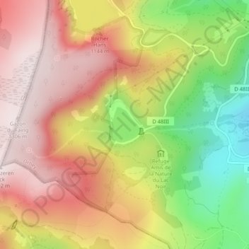
Name: Lac Noir topographic map, elevation, terrain.

Location: Lac Noir, Orbey, Colmar-Ribeauvillé, Haut-Rhin, Grand Est, Metropolitan France, 68370, France (48.11124 7.09467 48.11507 7.09935)

Average elevation: 1,052 m

Minimum elevation: 730 m

Maximum elevation: 1,297 m

Other topographic maps

Click on a map to view its topography, its elevation and its terrain.

Remomont

France > Grand Est > Haut-Rhin > Orbey

Average elevation: 696 m

Pairis

France > Grand Est > Haut-Rhin > Orbey

Average elevation: 801 m

Gear up for your next adventure:

Family Camping Tent - Spacious tent suitable for family camping trips
❄️Traction Ice Cleats - Slip-on spikes for icy trails and winter hiking
🧳Compression Sacks - Maximize space in your backpack by shrinking gear
🦟Insect Repellent - Keep mosquitoes and black flies away in wooded areas
Lightweight Camping Tent - Portable shelter optimized for Canadian backcountry camping

As an Amazon Associate, this site earns from qualifying purchases at no extra cost to you.