Geolocate

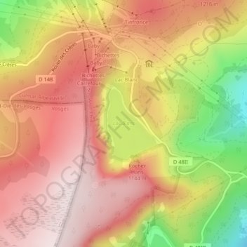
Lac Blanc topographic map

Click on the map to display elevation.

Lac Blanc

Lac Blanc is a lake in Haut-Rhin, France. At an elevation of 1055 m, its surface area is 0.29 km².

Wikipedia (CC-BY-SA 3.0)

About this map

Name: Lac Blanc topographic map, elevation, terrain.

Location: Lac Blanc, Orbey, Colmar-Ribeauvillé, Haut-Rhin, Grand Est, Metropolitan France, 68370, France (48.12326 7.08787 48.13094 7.09589)

Average elevation: 1,111 m

Minimum elevation: 806 m

Maximum elevation: 1,297 m

Other topographic maps

Click on a map to view its topography, its elevation and its terrain.

Remomont

France > Grand Est > Haut-Rhin > Orbey

Average elevation: 696 m

Pairis

France > Grand Est > Haut-Rhin > Orbey

Average elevation: 801 m

Gear up for your next adventure:

🧢Sun Protection Cap - Breathable cap to protect from sun exposure
🥾Mountaineering Boots - Supportive boots for climbing and high-altitude hiking
🧥Fleece Jacket - Warm and lightweight jacket for layering
🧢Hiking Sun Hat - Wide-brimmed protection for exposed mountain ridges
🧼Travel Hand Sanitizer - Keep hands clean when water is scarce

As an Amazon Associate, this site earns from qualifying purchases at no extra cost to you.