Geolocate

Poland topographic map

Click on the map to display elevation.

About this map

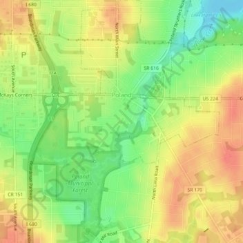
Name: Poland topographic map, elevation, terrain.

Location: Poland, Mahoning County, Ohio, 44514, United States (41.00387 -80.63092 41.03718 -80.59699)

Average elevation: 323 m

Minimum elevation: 294 m

Maximum elevation: 346 m

Other topographic maps

Click on a map to view its topography, its elevation and its terrain.

Austintown

United States > Ohio > Mahoning County

Average elevation: 318 m

Poland Center

United States > Ohio > Mahoning County

Average elevation: 336 m

Lake Milton

United States > Ohio > Mahoning County

Average elevation: 299 m

Austintown

United States > Ohio > Mahoning County

Average elevation: 318 m

Uptown

United States > Ohio > Mahoning County > Youngstown

Average elevation: 314 m

Fosterville

United States > Ohio > Mahoning County > Youngstown

Average elevation: 313 m

North Jackson

United States > Ohio > Mahoning County

Average elevation: 311 m

Stony Ridge

United States > Ohio > Mahoning County > Austintown

Average elevation: 310 m

North Lima

United States > Ohio > Mahoning County

Average elevation: 335 m

Gear up for your next adventure:

🧭GPS Tracker - Track your location in remote areas safely
🥾Mountain Hiking Shoes - Shoes with superior grip for mountainous terrain
🥾Hiking Boots - Sturdy boots providing ankle support and traction on rugged trails
🥾Hiking Leggings - Comfortable leggings for outdoor activities
🥾Mountain Hiking Boots - High-traction boots for rocky terrain

As an Amazon Associate, this site earns from qualifying purchases at no extra cost to you.