Geolocate

Oleiros topographic map

Click on the map to display elevation.

About this map

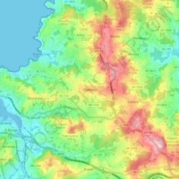
Name: Oleiros topographic map, elevation, terrain.

Location: Oleiros, A Coruña, Galicia, 15173, Spain (43.29306 -8.35708 43.37306 -8.27708)

Average elevation: 72 m

Minimum elevation: -1 m

Maximum elevation: 188 m

Other topographic maps

Click on a map to view its topography, its elevation and its terrain.

A Coruña

Spain > Galicia > A Coruña

Average elevation: 51 m

A Coruña

Spain > Galicia > A Coruña

Average elevation: 51 m

Abegondo

Spain > Galicia > A Coruña

Average elevation: 198 m

Carral

Spain > Galicia > A Coruña

Average elevation: 248 m

Tabeaio

Spain > Galicia > A Coruña

Average elevation: 157 m

A Coruña

Spain > Galicia > A Coruña

Average elevation: 51 m

A Coruña

Spain > Galicia > A Coruña

Average elevation: 51 m

A Coruña

Spain > Galicia > A Coruña

Average elevation: 51 m

Gear up for your next adventure:

🏃Hydration Running Vest - Carry water and maps close to your body for speed
🧦Outdoor Socks - Durable socks designed for hiking and outdoor sports
🧤Thermal Hiking Gloves - Grip-enhanced gloves for cold-weather altitude trekking
🌡️Emergency Mylar Blankets - Compact thermal protection for unexpected nights outdoors
🔦UV Flashlight - Detect minerals or specific insects in the dark

As an Amazon Associate, this site earns from qualifying purchases at no extra cost to you.