Geolocate

A Coruña topographic map

Click on the map to display elevation.

About this map

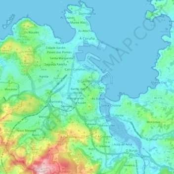
Name: A Coruña topographic map, elevation, terrain.

Location: A Coruña, Galicia, Spain (43.30324 -8.46916 43.39002 -8.37438)

Average elevation: 51 m

Minimum elevation: -1 m

Maximum elevation: 286 m

Other topographic maps

Click on a map to view its topography, its elevation and its terrain.

Monte Xalo

Spain > Galicia > A Coruña

Average elevation: 340 m

Punta Torrella

Spain > Galicia > A Coruña

Average elevation: 18 m

O Porto de Santa Cruz

Spain > Galicia > A Coruña

Average elevation: 40 m

Xuanzo

Spain > Galicia > A Coruña

Average elevation: 130 m

Salgueiros

Spain > Galicia > A Coruña > Quembre

Average elevation: 240 m

Oleiros

Spain > Galicia > A Coruña

Average elevation: 72 m

Gear up for your next adventure:

🧣Evaporative Cooling Towel - Beat the heat during intense summer climbs
🥫Freeze-Dried Meals - Lightweight, high-calorie nutrition for multi-day treks
🦟Insect Repellent - Keep mosquitoes and black flies away in wooded areas
🧥Waterproof Pants - Keep dry during rainy hiking conditions
🐕Hiking Dog Pack - Let your canine companion carry their own water and food

As an Amazon Associate, this site earns from qualifying purchases at no extra cost to you.