Geolocate

Carral topographic map

Click on the map to display elevation.

About this map

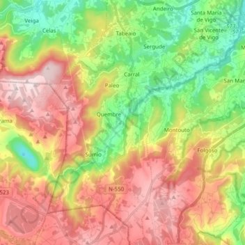
Name: Carral topographic map, elevation, terrain.

Location: Carral, A Coruña, Galicia, Spain (43.15185 -8.40873 43.26323 -8.28470)

Average elevation: 248 m

Minimum elevation: 5 m

Maximum elevation: 519 m

Other topographic maps

Click on a map to view its topography, its elevation and its terrain.

Punta Torrella

Spain > Galicia > A Coruña

Average elevation: 18 m

O Porto de Santa Cruz

Spain > Galicia > A Coruña

Average elevation: 40 m

Xuanzo

Spain > Galicia > A Coruña

Average elevation: 130 m

Monte Xalo

Spain > Galicia > A Coruña

Average elevation: 340 m

Salgueiros

Spain > Galicia > A Coruña > Quembre

Average elevation: 240 m

Oleiros

Spain > Galicia > A Coruña

Average elevation: 72 m

Gear up for your next adventure:

🧭GPS Handheld Device - Reliable GPS navigation for outdoor adventures
Lightweight Camping Tent - Portable shelter optimized for Canadian backcountry camping
👟Sport Hiking Sandals - Breathable footwear for water crossings and camp rest
🥾Lightweight Hiking Boots - Boots for comfort and mobility on long hikes
💡LED Headlamp - Hands-free illumination for night hiking and camping

As an Amazon Associate, this site earns from qualifying purchases at no extra cost to you.