
Tana Toraja Regency topographic map
Interactive map
Click on the map to display elevation.
About this map
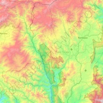
Name: Tana Toraja Regency topographic map, elevation, terrain.
Location: Tana Toraja Regency, South Sulawesi, 91817, Indonesia (-3.39005 119.37098 -2.73977 120.04472)
Average elevation: 1,314 m
Minimum elevation: 76 m
Maximum elevation: 3,406 m
Tana Toraja is centrally placed in the island of Sulawesi, 300 km north of Makassar, the provincial capital of South Sulawesi. It lies between latitude of 2°-3° South and longitude 119°-120° East (center: 3°S 120°E / 3°S 120°E / -3; 120Coordinates: 3°S 120°E / 3°S 120°E / -3; 120). The total area (since the separation of the new regency of North Toraja) is 2,054.30 km², about 4.4% of the total area of South Sulawesi province. The topography of Tana Toraja is mountainous; its minimum elevation is 150 m, while the maximum is 3,083 above the sea level.
Other topographic maps
Click on a map to view its topography, its elevation and its terrain.
Taka Bonerate National Park
Taka Bonerate National Park, South Sulawesi, Indonesia
Average elevation: 0 m
Bontoala
Indonesia > South Sulawesi > Makassar
Bontoala, Makassar, South Sulawesi, Indonesia
Average elevation: 7 m
Makassar
Indonesia > South Sulawesi > Makassar
Makassar, South Sulawesi, Indonesia
Average elevation: 15 m
Pangli Palawa
Indonesia > South Sulawesi > Pangli Palawa
Pangli Palawa, South Sulawesi, 99158, Indonesia
Average elevation: 831 m
Data
Indonesia > South Sulawesi > Data
Data, Galesong Selatan, South Sulawesi, Indonesia
Average elevation: 7 m
Sinri Jala
Indonesia > South Sulawesi > Sinri Jala
Sinri Jala, Galesong Selatan, South Sulawesi, 92300, Indonesia
Average elevation: 6 m
Buyu Balease
Buyu Balease, Luwu Utara, South Sulawesi, Indonesia
Average elevation: 2,668 m
Karuwisi
Indonesia > South Sulawesi > Karuwisi
Karuwisi, Galesong Selatan, South Sulawesi, 92300, Indonesia
Average elevation: 6 m
Wakatobi
Wakatobi, Luwu Utara, South Sulawesi, Indonesia
Average elevation: 795 m