Geolocate

Minas topographic map

Click on the map to display elevation.

About this map

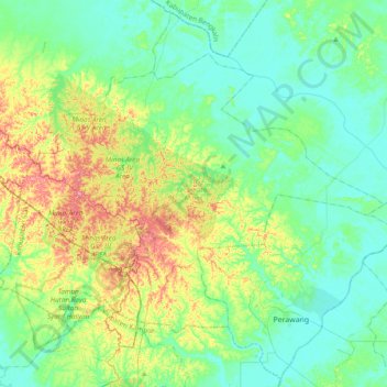
Name: Minas topographic map, elevation, terrain.

Location: Minas, Siak, Riau, Sumatra, Indonesia (0.63795 101.31119 0.92903 101.69457)

Average elevation: 31 m

Minimum elevation: -1 m

Maximum elevation: 101 m

Other topographic maps

Click on a map to view its topography, its elevation and its terrain.

Perawang

Indonesia > Riau > Siak

Average elevation: 12 m

Maredan

Indonesia > Riau > Siak

Average elevation: 7 m

Minas Barat

Indonesia > Riau > Siak

Average elevation: 64 m

Minas Jaya

Indonesia > Riau > Siak

Average elevation: 68 m

Siak Sri Indrapura

Indonesia > Riau > Siak

Average elevation: 5 m

Gear up for your next adventure:

🚑Survival Whistle - Signal for help across long distances in mountains
🥾Light Trekking Boots - Supportive boots for multi-day treks
🧴Insect Repellent - Protect yourself from bugs during outdoor adventures
🥾Hiking Shoes - Durable and comfortable shoes for trail hiking
🧤Insulated Winter Gloves - Heavy-duty protection for sub-zero Canadian adventures

As an Amazon Associate, this site earns from qualifying purchases at no extra cost to you.