
Westland District topographic map
Interactive map
Click on the map to display elevation.
About this map
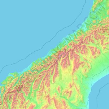
Name: Westland District topographic map, elevation, terrain.
Location: Westland District, West Coast, New Zealand (-44.49907 168.05287 -42.56006 171.88439)
Average elevation: 437 m
Minimum elevation: -1 m
Maximum elevation: 3,457 m
Other topographic maps
Click on a map to view its topography, its elevation and its terrain.
Ice Lake
New Zealand > West Coast > Westland District
Ice Lake, Westland District, West Coast, New Zealand
Average elevation: 1,343 m
Mt Baldy
New Zealand > West Coast > Buller District
Mt Baldy, Buller District, West Coast, New Zealand
Average elevation: 1,059 m
Smoothwater River
New Zealand > West Coast > Westland District
Smoothwater River, Westland District, West Coast, New Zealand
Average elevation: 175 m
Haast Pass
New Zealand > West Coast > Westland District
Haast Pass, Westland District, West Coast, New Zealand
Average elevation: 766 m
Mount Mackenzie
New Zealand > West Coast > Westland District
Mount Mackenzie, Westland District, West Coast, New Zealand
Average elevation: 1,636 m
Bruce Creek
New Zealand > West Coast > Grey District
Bruce Creek, Grey District, West Coast, New Zealand
Average elevation: 168 m