Geolocate

Pomarance topographic map

Click on the map to display elevation.

About this map

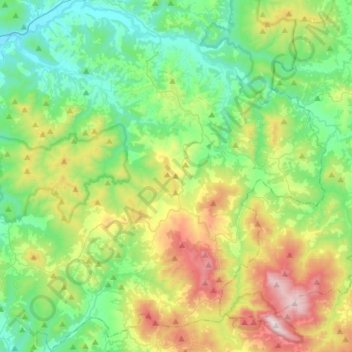
Name: Pomarance topographic map, elevation, terrain.

Location: Pomarance, Pisa, Tuscany, Italy (43.14134 10.72089 43.35580 10.95233)

Average elevation: 342 m

Minimum elevation: 44 m

Maximum elevation: 1,044 m

Other topographic maps

Click on a map to view its topography, its elevation and its terrain.

Montecastello

Italy > Tuscany > Pisa > Pontedera

Average elevation: 74 m

Santo Pietro Belvedere

Italy > Tuscany > Pisa

Average elevation: 68 m

Casciana Terme

Italy > Tuscany > Pisa

Average elevation: 150 m

Partino

Italy > Tuscany > Pisa > Palaia

Average elevation: 119 m

Montecalvoli

Italy > Tuscany > Pisa > Santa Maria a Monte

Average elevation: 33 m

Casciana Alta

Italy > Tuscany > Pisa

Average elevation: 136 m

Casciana Alta

Italy > Tuscany > Pisa

Average elevation: 136 m

Pieve di Santa Luce

Italy > Tuscany > Pisa

Average elevation: 140 m

Garetto Basso

Italy > Tuscany > Pisa > Chianni

Average elevation: 274 m

Ghizzano

Italy > Tuscany > Pisa > Peccioli

Average elevation: 103 m

Sassa

Italy > Tuscany > Pisa > Montecatini Val di Cecina

Average elevation: 228 m

San Casciano

Italy > Tuscany > Pisa > Cascina

Average elevation: 57 m

Gear up for your next adventure:

🧦Crew Hiking Socks - Comfortable socks for long-distance hikes
💡Portable Camping Lamp - Rechargeable lamp for campsite lighting
🥘Camping Cookware Set - Compact nesting pots and pans for trail cooking
🧥Thermal Fleece Jacket - Versatile insulation for changing mountain temperatures
🗺️Topographic Maps - Detailed maps to explore trails, mountains, and wilderness areas

As an Amazon Associate, this site earns from qualifying purchases at no extra cost to you.