Geolocate

Montecastello topographic map

Click on the map to display elevation.

About this map

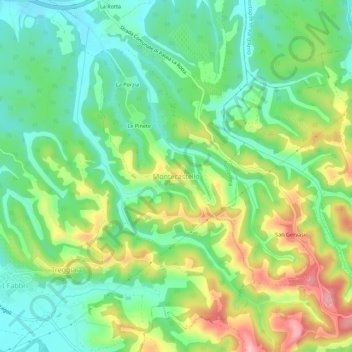
Name: Montecastello topographic map, elevation, terrain.

Location: Montecastello, Pontedera, Pisa, Tuscany, Italy (43.61461 10.67478 43.65461 10.71478)

Average elevation: 74 m

Minimum elevation: 15 m

Maximum elevation: 176 m

Gear up for your next adventure:

🧭GPS Handheld Device - Reliable GPS navigation for outdoor adventures
🛶Kayak Dry Bag - Waterproof storage for kayaking adventures
🔦UV Flashlight - Detect minerals or specific insects in the dark
🔨Vehicle Emergency Tool - Safety tool for remote road trips to trailheads
🛏️Sleeping Bag - Warm and compact sleeping bags for outdoor camping

As an Amazon Associate, this site earns from qualifying purchases at no extra cost to you.