Geolocate

Laura topographic map

Click on the map to display elevation.

About this map
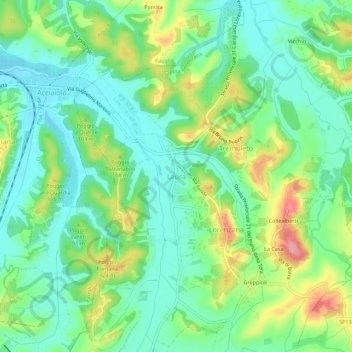
Name: Laura topographic map, elevation, terrain.

Location: Laura, Crespina Lorenzana, Pisa, Tuscany, 56043, Italy (43.52126 10.50721 43.56126 10.54721)

Average elevation: 65 m

Minimum elevation: 27 m

Maximum elevation: 142 m

Other topographic maps

Click on a map to view its topography, its elevation and its terrain.

Volterra

Italy > Tuscany > Pisa

Average elevation: 228 m

Pisa

Italy > Tuscany > Pisa

Average elevation: 11 m

Guardistallo

Italy > Tuscany > Pisa

Average elevation: 108 m

Terricciola

Italy > Tuscany > Pisa

Average elevation: 94 m

Castelnuovo di Val di Cecina

Italy > Tuscany > Pisa

Average elevation: 424 m

Volterra

Italy > Tuscany > Pisa

Average elevation: 228 m

Santa Maria a Monte

Italy > Tuscany > Pisa

Average elevation: 33 m

Montescudaio

Italy > Tuscany > Pisa

Average elevation: 111 m

Pomarance

Italy > Tuscany > Pisa

Average elevation: 342 m

Pisa

Italy > Tuscany > Pisa

Average elevation: 11 m

Monteverdi Marittimo

Italy > Tuscany > Pisa

Average elevation: 253 m

Chianni

Italy > Tuscany > Pisa

Average elevation: 300 m

Montescudaio

Italy > Tuscany > Pisa

Average elevation: 111 m

Castelnuovo di Val di Cecina

Italy > Tuscany > Pisa

Average elevation: 424 m

Pontedera

Italy > Tuscany > Pisa

Average elevation: 26 m

Pisa

Italy > Tuscany > Pisa

Average elevation: 11 m

Pontedera

Italy > Tuscany > Pisa

Average elevation: 26 m

Pomarance

Italy > Tuscany > Pisa

Average elevation: 342 m

Gear up for your next adventure:

🥾Approach Shoes - Shoes designed for climbing approaches and rugged trails
🧭GPS Tracker - Track your location in remote areas safely
🧥Ultralight Puffy Jacket - Maximum warmth that packs down to the size of an orange
🥽Outdoor Goggles - Protective eyewear for outdoor activities
🛏️Camping Sleeping Mat - Comfortable mats for sleeping outdoors

As an Amazon Associate, this site earns from qualifying purchases at no extra cost to you.