Geolocate

Wuling District topographic map

Click on the map to display elevation.

About this map

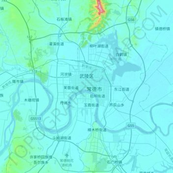
Name: Wuling District topographic map, elevation, terrain.

Location: Wuling District, Changde, Hunan, China (28.88921 111.58269 29.22496 111.84204)

Average elevation: 52 m

Minimum elevation: 23 m

Maximum elevation: 532 m

Other topographic maps

Click on a map to view its topography, its elevation and its terrain.

Xinpu

China > Hunan > Changde

Average elevation: 259 m

Gear up for your next adventure:

🧥Softshell Hiking Jacket - The perfect balance of wind protection and breathability
🧢Beanie Hat - Keep your head warm in cold weather
🧦Crew Hiking Socks - Comfortable socks for long-distance hikes
👟Leg Gaiters - Keep debris, mud, and snow out of your boots
💡LED Camping Lantern - Illuminate your campsite with long-lasting lanterns

As an Amazon Associate, this site earns from qualifying purchases at no extra cost to you.