Geolocate

Frisa topographic map

Click on the map to display elevation.

About this map

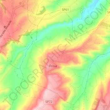
Name: Frisa topographic map, elevation, terrain.

Location: Frisa, Chieti, Abruzzo, Italy (42.24550 14.34974 42.28683 14.41126)

Average elevation: 164 m

Minimum elevation: 48 m

Maximum elevation: 280 m

Other topographic maps

Click on a map to view its topography, its elevation and its terrain.

Vallone di Santo Spirito

Italy > Abruzzo > Chieti > Fara San Martino

Average elevation: 1,273 m

Buonanotte

Italy > Abruzzo > Chieti > Vasto

Average elevation: 43 m

Fallascoso

Italy > Abruzzo > Chieti > Torricella Peligna

Average elevation: 839 m

Casali

Italy > Abruzzo > Chieti > Schiavi di Abruzzo

Average elevation: 734 m

Coderuto

Italy > Abruzzo > Chieti > Torrevecchia Teatina

Average elevation: 77 m

Foro

Italy > Abruzzo > Chieti > Miglianico

Average elevation: 143 m

Aquilano

Italy > Abruzzo > Chieti > Ortona > Aquilano

Average elevation: 86 m

Gear up for your next adventure:

🩹Compact First Aid Kit - Pre-packed essentials for common trail injuries
🧭GPS Tracker - Track your location in remote areas safely
🧦Hiking Liner Socks - Thin base layer to prevent friction and blisters
🏃Hydration Running Vest - Carry water and maps close to your body for speed
🧦Outdoor Socks - Durable socks designed for hiking and outdoor sports

As an Amazon Associate, this site earns from qualifying purchases at no extra cost to you.