
Paxson topographic map
Click on the map to display elevation.
Paxson
Paxson has a continental subarctic climate (Köppen Dfc), closely bordering on an alpine climate (Köppen ET) due to its high elevation and northerly latitude, with only one month above the 50 degree isotherm.
About this map
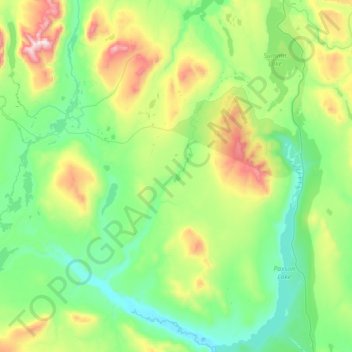
Name: Paxson topographic map, elevation, terrain.
Location: Paxson, Unorganized Borough, Alaska, United States (62.84557 -146.10906 63.17183 -145.45031)
Average elevation: 1,015 m
Minimum elevation: 747 m
Maximum elevation: 1,895 m
Other topographic maps
Click on a map to view its topography, its elevation and its terrain.
Kasatochi Island
United States > Alaska > Unorganized Borough
Kasatochi Island is a member of the Aleutian Islands, which lie above a narrow ridge that separates the Bering Sea from the North Pacific. It lies at the Atka Pass northwest of the western tip of Atka Island and east of Great Sitkin Island. It is at 52.177° N latitude and 175.508° W longitude, with a summit…
Average elevation: 53 m
Denali's Fault. Scenic overlook
United States > Alaska > Unorganized Borough > Delta Junction
Average elevation: 379 m