
开封市 topographic map
Interactive map
Click on the map to display elevation.
About this map
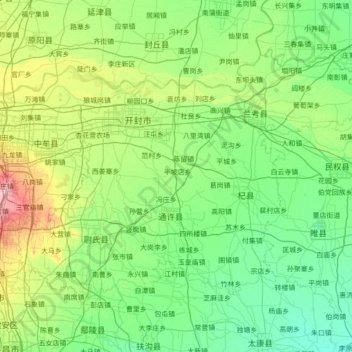
Name: 开封市 topographic map, elevation, terrain.
Location: 开封市, 河南省, 中国 (34.19523 113.86551 35.02605 115.26151)
Average elevation: 70 m
Minimum elevation: 47 m
Maximum elevation: 175 m
开封市所在的豫东平原位于黄河下游大冲积扇南翼,属黄河冲积平原,第四系全新地层,其成因为黄河冲积物,质地疏松。海拔69米至78米。这里地势平坦,土层深厚,土质良好,结构稳定,有利于各种农作物和经济作物的种植,林木覆盖率高。
Other topographic maps
Click on a map to view its topography, its elevation and its terrain.
河南省安阳师范学院家属院-家
河南省安阳师范学院家属院-家, 平原路, 紫薇大道街道, 开发区银杏大街街道, 文峰区, 安阳市, 河南省, 455000, 中国
Average elevation: 69 m