Geolocate

Dunlap topographic map

Click on the map to display elevation.

About this map

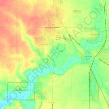
Name: Dunlap topographic map, elevation, terrain.

Location: Dunlap, Peoria County, Illinois, United States (40.82400 -89.70303 40.86792 -89.64909)

Average elevation: 212 m

Minimum elevation: 181 m

Maximum elevation: 236 m

Other topographic maps

Click on a map to view its topography, its elevation and its terrain.

Trivoli

United States > Illinois > Peoria County

Average elevation: 224 m

Monica

United States > Illinois > Peoria County

Average elevation: 230 m

Kickapoo

United States > Illinois > Peoria County

Average elevation: 198 m

Peoria

United States > Illinois > Peoria County > Peoria

Average elevation: 196 m

Gear up for your next adventure:

🧦Outdoor Socks - Durable socks designed for hiking and outdoor sports
🩹Compact First Aid Kit - Pre-packed essentials for common trail injuries
Camping Coffee Maker - Brew fresh coffee anywhere on the topographic map
💧Filtered Water Bottle - Safe drinking water on the go
🥾Trail Hiking Shoes - Durable shoes designed for rugged trails

As an Amazon Associate, this site earns from qualifying purchases at no extra cost to you.