Geolocate

Harrison topographic map

Click on the map to display elevation.

About this map

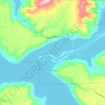
Name: Harrison topographic map, elevation, terrain.

Location: Harrison, Kootenai County, Idaho, United States (47.43300 -116.83908 47.49760 -116.75676)

Average elevation: 745 m

Minimum elevation: 644 m

Maximum elevation: 1,061 m

Other topographic maps

Click on a map to view its topography, its elevation and its terrain.

Bellgrove

United States > Idaho > Kootenai County

Average elevation: 802 m

Cataldo

United States > Idaho > Kootenai County

Average elevation: 732 m

Mica

United States > Idaho > Kootenai County

Average elevation: 785 m

Mica Peak

United States > Idaho > Kootenai County

Average elevation: 1,131 m

Bayview

United States > Idaho > Kootenai County

Bayview is an unincorporated community in the northwest United States, located in Kootenai County, Idaho, north of Coeur d'Alene. On the southwest shore of Lake Pend Oreille, Bayview is seven miles (11 km) east-northeast of Athol. The community is served by State Highway 54 and a post office with ZIP code…

Average elevation: 733 m

Cataldo

United States > Idaho > Kootenai County

Average elevation: 732 m

Eddyville

United States > Idaho > Kootenai County

Average elevation: 738 m

Hayden

United States > Idaho > Kootenai County

Average elevation: 717 m

Gear up for your next adventure:

🧢Outdoor Cap - Protective cap for sun and rain during hikes
🔋Solar Power Bank - Keep your GPS and devices charged during long outdoor trips
🛁Quick-Dry Microfiber Towel - Space-saving towel that dries rapidly on the move
🧴Sunscreen SPF - Broad-spectrum sunscreen for outdoor activities
Camping Coffee Maker - Brew fresh coffee anywhere on the topographic map

As an Amazon Associate, this site earns from qualifying purchases at no extra cost to you.