Geolocate

Mabacan topographic map

Click on the map to display elevation.

About this map

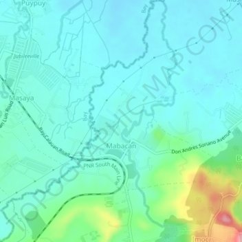
Name: Mabacan topographic map, elevation, terrain.

Location: Mabacan, Calauan, Laguna, Calabarzon, 4012, Philippines (14.12076 121.27225 14.15800 121.30395)

Average elevation: 34 m

Minimum elevation: 7 m

Maximum elevation: 147 m

Other topographic maps

Click on a map to view its topography, its elevation and its terrain.

Mount Mabilog

Philippines > Laguna > Calauan

Average elevation: 152 m

Balayhangin

Philippines > Laguna > Calauan

Average elevation: 87 m

Kalisungan

Philippines > Laguna > Calauan

Average elevation: 293 m

Imoc Hill

Philippines > Laguna > Calauan

Average elevation: 148 m

Lamot 2

Philippines > Laguna > Calauan

Average elevation: 110 m

Gear up for your next adventure:

🧢Beanie Hat - Keep your head warm in cold weather
💡Compact LED Flashlight - Powerful and portable flashlight for outdoor use
🥾Hiking Gaiters - Protect legs and shoes from mud, snow, and debris
💡LED Camping Lantern - Illuminate your campsite with long-lasting lanterns
🧼Biodegradable Camp Soap - Environmentally friendly cleaning for gear and body

As an Amazon Associate, this site earns from qualifying purchases at no extra cost to you.