Geolocate

Lamot 2 topographic map

Click on the map to display elevation.

About this map

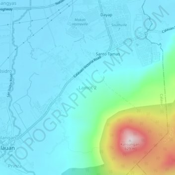
Name: Lamot 2 topographic map, elevation, terrain.

Location: Lamot 2, Calauan, Laguna, Calabarzon, 4012, Philippines (14.13914 121.31462 14.17914 121.35462)

Average elevation: 110 m

Minimum elevation: 6 m

Maximum elevation: 637 m

Other topographic maps

Click on a map to view its topography, its elevation and its terrain.

Perez

Philippines > Laguna > Calauan

Average elevation: 82 m

Mabacan

Philippines > Laguna > Calauan

Average elevation: 34 m

Imoc

Philippines > Laguna > Calauan

Average elevation: 125 m

Masiit

Philippines > Laguna > Calauan

Average elevation: 12 m

Masiit

Philippines > Laguna > Calauan

Average elevation: 12 m

Masiit

Philippines > Laguna > Calauan

Average elevation: 12 m

Perez

Philippines > Laguna > Calauan

Average elevation: 82 m

Mabacan

Philippines > Laguna > Calauan

Average elevation: 34 m

Silangan

Philippines > Laguna > Calauan

Average elevation: 24 m

Dayap

Philippines > Laguna > Calauan

Average elevation: 19 m

Gear up for your next adventure:

🧥Packable Rain Jacket - Breathable waterproof layer for unpredictable weather
🧭GPS Outdoor Watch - Smart watch for navigation and fitness tracking in nature
🔦UV Flashlight - Detect minerals or specific insects in the dark
🔦LED Headlamp - Hands-free lighting for early morning starts or late finishes
🥾Waterproof Hiking Boots - Boots keeping your feet dry in wet conditions

As an Amazon Associate, this site earns from qualifying purchases at no extra cost to you.