Geolocate

Imoc Hill topographic map

Click on the map to display elevation.

About this map
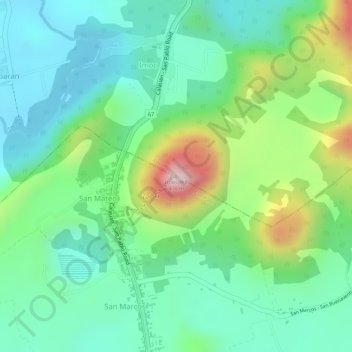
Name: Imoc Hill topographic map, elevation, terrain.

Location: Imoc Hill, Calauan, Laguna, Calabarzon, 4012, Philippines (14.11261 121.30427 14.11271 121.30437)

Average elevation: 148 m

Minimum elevation: 37 m

Maximum elevation: 386 m

Other topographic maps

Click on a map to view its topography, its elevation and its terrain.

Dayap

Philippines > Laguna > Calauan

Average elevation: 19 m

Silangan

Philippines > Laguna > Calauan

Average elevation: 24 m

Mabacan

Philippines > Laguna > Calauan

Average elevation: 34 m

Perez

Philippines > Laguna > Calauan

Average elevation: 82 m

Masiit

Philippines > Laguna > Calauan

Average elevation: 12 m

Imoc

Philippines > Laguna > Calauan

Average elevation: 125 m

Masiit

Philippines > Laguna > Calauan

Average elevation: 12 m

Masiit

Philippines > Laguna > Calauan

Average elevation: 12 m

Mabacan

Philippines > Laguna > Calauan

Average elevation: 34 m

Perez

Philippines > Laguna > Calauan

Average elevation: 82 m

Gear up for your next adventure:

🧣Merino Neck Gaiter - Protects against wind, sun, and cold at high altitudes
🏕️Camping Hammock - Integrated protection for sleeping between trees
🕶️Polarized Sunglasses - Protect your eyes with durable polarized lenses
🧊Insulated Water Bottle - Keeps drinks cold in summer and prevents freezing in winter
🧴Outdoor Sunscreen - High SPF protection for high-altitude UV exposure

As an Amazon Associate, this site earns from qualifying purchases at no extra cost to you.